![Cycling Loveland Pass South Cycling Loveland Pass South - photo collage, PJAMM Cycling logo in corner, road sign for Loveland Pass Summit, cyclist on bike in front of Loveland Pass Continental Divide sign, cyclist climbing on roadway]()
Cycling Loveland Pass South, Colorado
Ride 8.5 miles gaining 2,652’ at 5.9% average grade.
![Cycling Loveland Pass South Cycling Loveland Pass South - both sides of Highway 6, going towards forested mountainside]()
The climb begins by riding northeast up Highway 6 from Keystone Resort.
Climb report by Mike Persellin, Robbinsdale, MN, USA:
Loveland South has two faces, really. From the start at Keystone resort, it’s a uninteresting, steady 5-7% for five miles up to the ski resort of Arapahoe Basin. Then, after a sweeping S-turn, you’re into beautiful alpine meadows and pines until another two S-turns take you above the treeline and past a couple of small icy-looking lakes to the finish. The summit sign and the piles of snow and ice remind you that you are now at 12,003 feet. It’s cold up there, so bring your warmers. There are expansive views in several directions. The climb is not difficult -- the grade is steady and never makes it into double digits. There is very little traffic on US 6, just the occasional tanker truck not allowed through the Loveland Tunnel below. The pavement is excellent and there is a good shoulder. Like almost all the climbs in this part of Colorado, you start above 9,000 feet, so altitude is an issue.
![Cycling Loveland Pass South Cycling Loveland Pass South - photo collage, PJAMM Cycling logo in corner, climb gradient, cyclist on two lane highway along mountainside, stretch of mountains visible from roadway]()
Climb report by Erich Pawelka, Vienna, Austria:
The real climb starts at Keystone. I stayed in Silverthorne and started the ride from there. From Silverthorne it is a very easy approximately 10 mile climb (most of the time you don't realize it is uphill until you are in Keystone). There is a very nice bicycle trail from Silverthorne all the way to Keystone, and I would strongly recommend to take the nice bike trail to Keystone and not the Highway. In general most of the area is covered with bicycle trails. It doesn't matter if you start in Silverthorne, Dillon, Frisco, or Breckenridge. Bike paths lead from all of these cities to Lake Dillon (and around) and from there to Keystone.
In Keystone (which is a skiing area) there are some shops where you can fill up your water, and get some food if you need it. I am not 100% sure if these shops are open all year round but they were open at the beginning of May, which is pretty off season.
![Cycling Loveland Pass South Cycling Loveland Pass South - photo collage, PJAMM Cycling logo in corner, Loveland Pass in the winter, covered in snow]()
Erich proves the pass can be ridden in the winter . . .
From there the real climb starts. The first 200 metres or so don’t look very inviting as the climbs starts off from the highway which you have to cross (but there was very light traffic), and there is a very narrow shoulder. However don’t let yourself be deterred by that. As soon as you pass the first curve (about 200 metres) the shoulder gets wider and the ride is really beautiful from there on. There is very light traffic (at least in May), most of the cars don't go too fast and the road is wide enough for them to make room.
A little more than halfway up (between mile 4 and 4.5) there is another skiing area with a restaurant and shop where you could fill up your provisions if you wanted. The restaurant was still open in May, but I don't know if it is open all summer.
The road condition is very good nearly all the way to the top and only during the last 1-1.5 miles, the road gets a little rougher (but still very good).
In my opinion the climb is perfect to prepare for Mt. Evans and Pikes Peak. The gradient is very steady and never gets too steep (5-7%) and you get used to the high altitude as it takes you up to 3656 metres (11995 feet).
Downhill is also really nice because of the good and wide road. And, if you happen to get caught in a snowstorm (like me!) you can warm up at the Ski area halfway up or in Keystone, and in case of any emergency, there are still enough cars using the pass so you can always stop a vehicle if you need to.
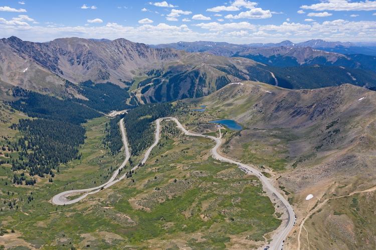
![Cycling Loveland Pass South Cycling Loveland Pass South - aerial drone view of switchbacks last two miles of climb]()
Aerial view looking from summit towards the two giant switchbacks along the last two miles to the top.
![Cycling Loveland Pass South Cycling Loveland Pass South - photo collage, PJAMM Cycling logo in corner, cyclists wearing PJAMM Cycling jerseys standing with bikes in front of sign for Loveland Pass, Continental Divide, cars parked along side of roadway at summit]()

 We've partnered with Sherpa-Map.com to bring you the best route planning tool. With a PRO Membership you can use this climb as a reference when creating your route.


